Classification of Ground water
Classification of Groundwater for Irrigation use at Dhanbad Town Area
Anshul Jain1, SR Kumar2, KDSR Prashant1 and J. Ravi Kiran1
1ISM, Dhanbad , 2CFMS-NIH, Patna
Abstract
In the present study, Doneen’s (1964) Permeability Index method has been used for classifying the groundwater quality in three different classes to understand its irrigation suitability at Dhanbad. For this purpose groundwater quality data were collected from 24 different hand pumps of the Dhanbad town area and analysed and analysed them for their electrical conductivity (EC), Na+, Ca2+ and Mg2+ concentrations to acquire the required information.
Keywords: Doneen’s Permeability Index, Irrigation Water Quality, Dhanbad, Groundwater
Introduction
Water quality is influenced by natural and anthropogenic effects including local climate, geology and irrigation practices. The water quality used for irrigation is essential for the yield and quantity of crops, maintenance of soil productivity and protection of the environment. Irrigation with poor quality waters may bring undesirable elements to the soil in excessive quantities affecting its fertility. Once undesirable constituents enter the ground it is difficult to control their dissolution. To cope up with such problems, the information concerning the quality of irrigation water and its effect on soils and crops is necessary (Ayers and Branson, 1975). Intensive agricultural activities have increased the demand on water resources in India. Therefore, water quality issues and its management need to be given greater attention.
Study Area
The Dhanbad district is situated in the state of Jharkhand and lies between 23º37’3″ and 24º4′ North latitude and between 86º6´30″ and 86o50′ East longitude. Dhanbad district shares its boundaries with West Bengal in the eastern and south part Dumka and Giridih district in North and Bokaro district in West. It is about 500-1000 ft. above sea level. Dhanbad comes under the Chota-Nagpur Plateau.
The climate of Dhanbad is tropical in nature with hot summer. In winter, the minimum temperature remains around 8ºC with a maximum of 22ºC. Dhanbad town which have been taken into consideration for the study cover an area between G.T. Road and Bank More in S direction and between Govindpur East and Hirak Bye pass Road in E-W direction (Fig. 1).
Geology and Groundwater
The rocks beneath Dhanbad and its adjoining terrains are metamorphic rocks made up of older basement rocks – Mica-Schist, Amphibolites, quartze-felspatite, sniessis and granitite. These older basement rocks have been intruded by Dolerite and then by acid intrusive rock layers of quartzite, etc. Though, metamorphic rocks are impermeable but some associated fissured rock layers are in aquifers which might have joined with fault planes or shear planes but their exact location and depth are not known exactly. Their depth differs from place to place. Therefore, in deep borings for water, it has been found that at a particular location, no water is found, but in the same vicinity few meters near about water is found. Such phenomena have been found at many locations during deep tube well boring for water. Dhanbad town and its surrounding areas have moderately thick confined or unconfined aquifers beneath the surface.
Methodology
Conductivity had been analyzed at the site using field testing kit and the remaining parameters like calcium, magnesium and sodium concentrations have been analysed in the laboratory as per the standard methods of APHA (1995).
Results and Discussions
The soil permeability is affected by long term use of irrigation water. It is influenced by sodium, calcium, magnesium and bicarbonate contents of soil. High concentrations of exchangeable sodium in irrigation waters and soils cause the eventual deterioration of soil structure and resulting reduction in hydraulic conductivity. When calcium and magnesium are the predominant cations occupying soil exchange sites, soils tend to have a granular structure that is readily permeable to both air and water. As the concentration of exchangeable sodium in the soil increases, the ratio of sodium to calcium and magnesium ions rises and the number of exchange sites occupied by calcium or magnesium decreases. This causes soil mineral particles to disperse and hydraulic conductivity to decrease (Rhoades, 1982).
The guideline for interpreting water quality can be used to identify potential problems in the use of the particular quality of water for crop irrigation. Usually the quality of groundwater for irrigation purpose is evaluated on the basis of total concentration of soluble salts or salinity hazards, exchangeable sodium or sodicity hazards, toxicity hazards due to specific constituents and other miscellaneous effects. Classification offers great advantages in groundwater management as it provides a short, quick processing, interpretation for a lot of complete hydro-chemical data sets and concise presentation of results.
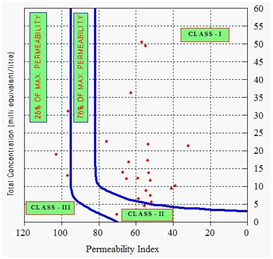
Doneen (1964) has evolved a criterion for assessing the suitability of groundwater for irrigation based on Permeability Index (PI). He has developed a chart based on permeability index (PI) for classification of irrigation water for soils of medium permeability. The permeability index (PI) is calculated as below:
PI = [Na+ + SQRT (HCO–3)] / (Ca2+ + Mg2+ + Na+)
where all the ionic concentrations are expressed in epm.
According to this classification, water is good if:
- It belongs to CLASS-I or II in the Doneen (1964) chart (Raghunath, 1987).
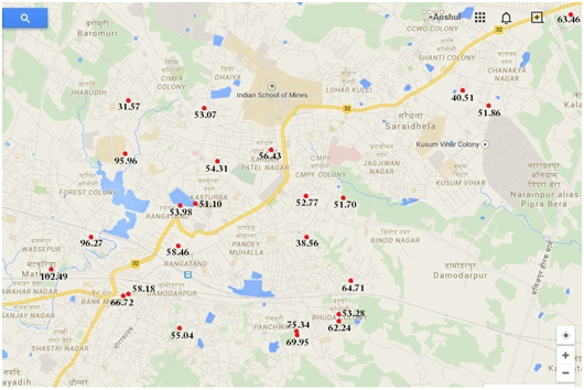
Fig.1 represents the study area, marked with all sampling sites and corresponding permeability index.
The statistical measures such as minimum, maximum, average, median, mode etc. are presented in Table-1 for the experimental analysis (conductivity, Na+, Ca2+, Mg2+ and HCO–3), Total salts(TDS) and Doneen’s PI of the all 24 sites.
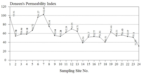
The Table-2 represents the Doneen’s PI values and corresponding suitability class for the each sampling site. Fig. 2 represents the graphical comparison of Doneen’s PI values at various sampling locations.
Doneen’s PI plot for the study area is presented in Fig. 3. It is the graphical representation of the study results.
Table 1 : Statistical analysis of various parameters
| Descriptive Statistics | Total Salts (meq) | Na+ (meq) | Ca2+ (meq) | Mg2+ (meq) | HCO–3 (meq) | Doneen’s PI |
| Minimum | 1.98 | 0.06 | 0.70 | 0.02 | 0.14 | 31.57 |
| Maximum | 50.54 | 13.64 | 10.04 | 3.48 | 7.44 | 102.49 |
| Mean | 17.38 | 4.43 | 3.02 | 0.98 | 0.88 | 60.75 |
| Median | 13.38 | 2.98 | 2.49 | 0.80 | 0.43 | 55.73 |
| Standard Deviation | 12.91 | 4.10 | 2.34 | 0.92 | 1.56 | 17.37 |
| Kurtosis | 1.79 | 0.47 | 3.10 | 2.92 | 15.02 | 1.15 |
| Skewness | 1.48 | 1.24 | 1.82 | 1.72 | 3.81 | 1.06 |
| Coeff. of Var. % | 74.26 | 92.67 | 77.56 | 93.54 | 177.13 | 28.59 |
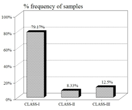
The % frequency of samples in various classes has been represented in Fig.4. It is clear from the figure that about 80% samples of groundwater is falling under Class-I category, i.e. can be used unobjectionably for the irrigation purposes. However, precaution should be taken before using the groundwater for irrigation near the sites which fall in Class-III.
Table2 : Doneen’s PI and corresponding class of suitability
| Site No. | Sampling site | Doneen’s P.I. Value | Class | Site No. | Sampling site | Doneen’s P.I. Value | Class | |
| 1. | Polytechnic college | 95.96 | CLASS-III | 13. | Chiragora | 64.71 | CLASS-I | |
| 2. | Grewal colony | 53.98 | CLASS-I | 14. | Hari mandir | 38.56 | CLASS-I | |
| 3. | Railway colony | 58.46 | CLASS-I | 15. | Telipara | 51.70 | CLASS-I | |
| 4. | Bank more thana | 58.18 | CLASS-I | 16. | Heerapur | 52.77 | CLASS-I | |
| 5. | Municipal office | 66.72 | CLASS-I | 17. | Saraidhela | 51.86 | CLASS-I | |
| 6. | Washepur masjid | 96.27 | CLASS-III | 18. | Steel gate | 40.51 | CLASS-I | |
| 7. | Matkuria | 102.49 | CLASS-III | 19. | Bhojpur mandir | 63.46 | CLASS-I | |
| 8. | Barmasia | 75.34 | CLASS-I | 20. | Dhaiya | 54.31 | CLASS-I | |
| 9. | Gandhi nagar | 55.04 | CLASS-II | 21. | Housing colony | 56.43 | CLASS-I | |
| 10. | Gaguatard | 53.28 | CLASS-I | 22. | CIMFR campus | 53.07 | CLASS-I | |
| 11. | Tikkiapara | 62.24 | CLASS-I | 23. | Bekar Bandh | 51.10 | CLASS-I | |
| 12. | Barmasia | 69.95 | CLASS-II | 24. | Bishnupur | 31.57 | CLASS-I |
Conclusion
Water is the next important input to fertilizer for crop production. If it is polluted, it may be dangerous for plants, animals as well as for human being. Before using water for irrigation, its quality, which is equally important to its quantity, should be assessed so that it could not create any health hazard. If low quality of water is utilized for irrigation, soluble salts and /or other toxic elements may accumulate in the soil thus deteriorating soil properties and crop quality. Good quality water helps maintaining agricultural productivity and sustaining soil fertility.
The hydro geochemical analysis according to Doneen’s Permeability Index reveals that 79.17% samples are falling underCLASS-I (good for irrigation), 8.33% samples are fallingin CLASS-II and remaining12.50% falls underCLASS-III category. Groundwater near 3 stations (site no. 1, 6, 7) which fall in CLASS-IIIshould be avoided for irrigation purpose and other surface water sources should be utilised to meet the irrigationneeds.
The overall study and analytical results show that the groundwater is good for the irrigational uses except few locations. However, the quality of soil and its ionic constituents should be necessarily analysed before employing the groundwater for irrigation purpose near the locations which fall underCLASS-III classification of Doneen’s PI criteria.
References
1. APHA (1995). Standards Methods in the Examination of Water and Waste Water, 17th Ed., Washington, D.C.10.
2. Ayers, R.S. and Branson, R.L. (1975). Guidelines for Interpretation of Water Quality for Agriculture, University of California. Extension Mimeographed, 13 p.
3. Doneen, L.D. (1964). Notes on Water Quality in Agriculture, Water Science and Engineering Paper 4001, Dept. of Water, Science and Engineering, Univ. of California, Davis, USA.
4. Raghunath, H.M. (1987). Ground Water, Wiley Eastern Limited, New Delhi, India, 456 p.
5. Rhoades, J.D. (1982). Reclamation and Management of Salt affected Soils after Drainage. Proc. 1st Annual Western Provincial Cong. on Water and Soil Resources Management. Lethbridge, Alberta Canada. pp 123-197.